"Weather Bomb" Headed for Vancouver Island
We're not strangers to powerful squalls and extreme winds but what's heading for Vancouver Island over the next few days could be biblical.
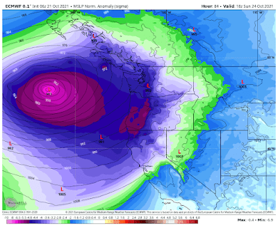
Report authors note that the first storm is in the midst of an "explosive cyclogenesis, a drop in pressure of at least 24 millibars in 24 hours - qualifying it in popular parlance as a 'weather bomb." However, this system is expected to do "twice the amount of strengthening" needed to meet that definition."While this is the wet season for the west coast, and they are no stranger to strong lows at this time of year, two back-to-back powerhouse systems like these are certainly something to take note of," says Nadine Powell, a meteorologist at The Weather Network.
The storm will also be strengthened by the "remnants from a western Pacific typhoon," explain report authors, which will increase the amount of rainfall.
Low #2 will be stronger, belongs in the Bering Sea, but instead, it'll be southwest of Vancouver Island Sunday PM. It's unprecedented in terms of pressure. Still, lots of questions on the wind field, strongest just south of the centre, decays on approach - it's honestly weird.
Update: This is weird. When I awoke this morning everything outside was perfectly still. Not a leaf rustling. Even the birds seem to be hunkering down in the cedars. There was blue sky but that's gone now. I have this feeling that this eerie stillness is about to change - real fast.

We had the effects of an 'atmospheric river' in Vancouver, on Thanksgiving wknd.
ReplyDeleteNow this!
Funny, your post prompted me to google "undulating jet stream 2021" as I suspect it may be part of the picture here.
The two top search results were
https://www.carbonbrief.org/jet-stream-is-climate-change-causing-more-blocking-weather-events
and then
https://electroverse.net/the-changing-jet-stream-and-global-cooling/
It seemed so appropriate for these BS times of "we present both sides and YOU decide" and the imminent death of empiricism.
Hadley Cells and Rossby Waves, NPoV. Do you remember in 2013 when Calgary got its second "once a century" flooding in the span of just five years? That resulted from a torrential rainstorm that parked itself over the foothills for several days. Another example was the Atlanta Big Freeze.
DeleteThe following year it was Atlanta's turn for weird weather. An ice storm hit Georgia at the end of January. Traffic was stuck for days. At the same time residents of Barrow, Alaska were basking in low-60s temperatures. Rossby waves were bringing warm winds out of the south to the far north and Arctic winds down to Georgia. Today we're accustomed to winter heatwaves inside the Arctic Circle even in the 24-hour darkness of winter.
Aren't you glad this is all a hoax?